

Inertial Navigation - Quick Start
Welcome to iMAR Navigation: Precision Inertial Navigation Solutions
At iMAR Navigation, we specialize in cutting-edge inertial measurement systems (IMS) that offer unparalleled accuracy and reliability for various applications. With over 30 years of experience in sensor data fusion and integration, our innovative solutions cater to industries such as aerospace, automotive, marine, and military.
Our Expertise
Our team of skilled engineers and scientists leverage state-of-the-art technologies, including MEMS, FOG, HRG and RLG sensors, to deliver customized solutions that meet the unique demands of our clients. We understand that each application is different, which is why we offer tailored solutions, from prototypes to production batches of thousands of devices.
Advanced Technologies for Enhanced Performance
At iMAR, we ensure that our inertial measurement systems provide:
- High Accuracy: Our systems are designed to achieve superior roll and pitch accuracy, ensuring reliable performance even in challenging environments.
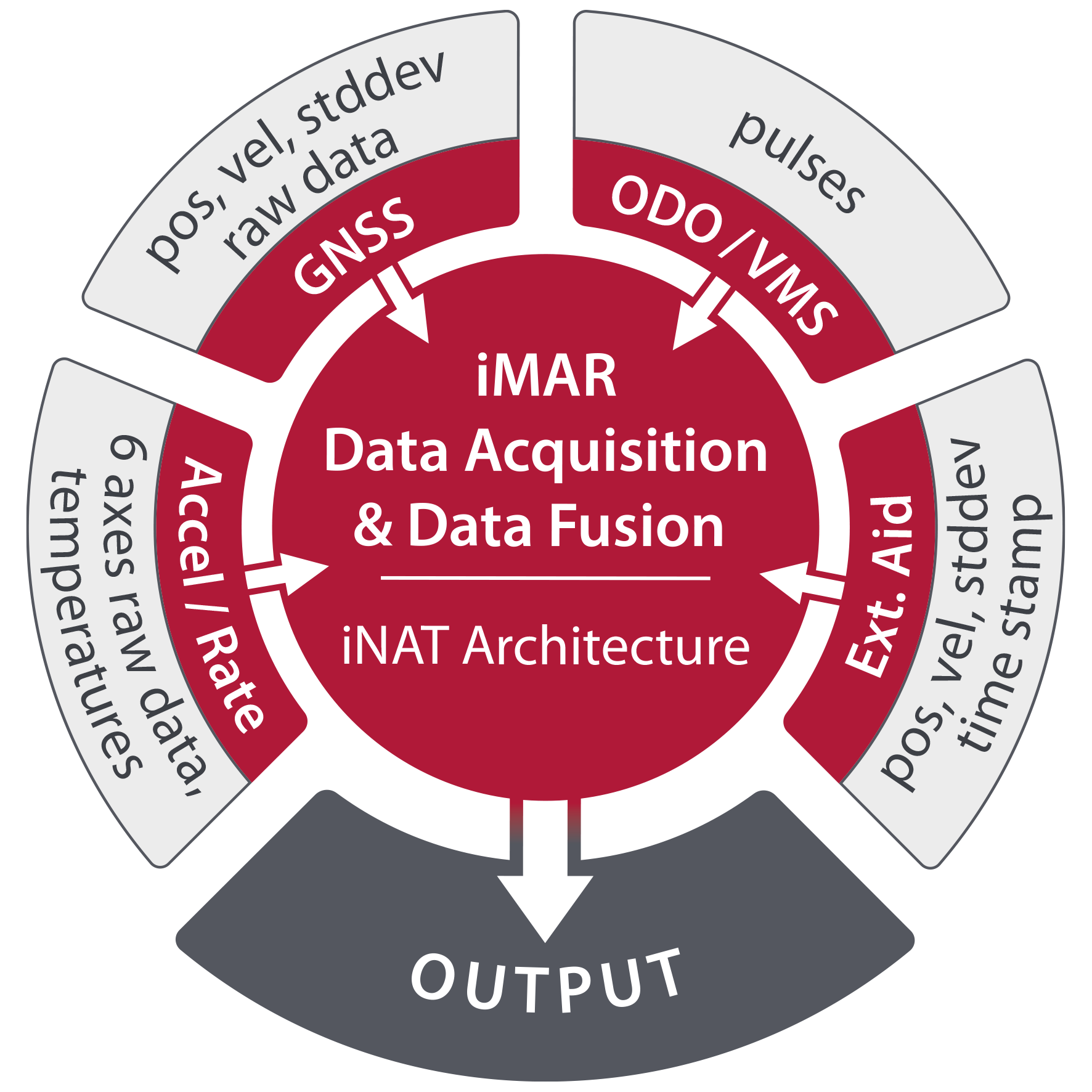
- Real-Time Data Processing: We offer robust and efficient data interfaces, allowing seamless communication between our IMS and external sensors such as GNSS, LiDAR, and cameras.
- User-Friendly Interfaces: Our systems come with intuitive graphical user interfaces (GUIs) for easy configuration, real-time data visualization, and maintenance features.
Applications of Our Inertial Measurement Systems
iMAR Navigation’s solutions are ideal for a variety of applications, including:
- Autonomous Vehicle Guidance: Ensure precise control and stability for unmanned vehicles.
- Surveying and Mapping: Achieve high accuracy in land surveys with our advanced inertial navigation technology.
- Aerial Laser Scanning: Enhance data collection and analysis for topographic mapping and environmental monitoring. Major activities are also related to rad and railway monitoring with our LiDAR / INS solutions.
- Pipeline Inspection: Utilize our systems for reliable monitoring and inspection of pipelines and other critical infrastructure.
- Gyro Stabilized Platform: Ensure precise pointing and tracking with camera and antenna systems on moving vessels.
Commitment to Quality and Reliability
Our commitment to quality is reflected in our adherence to rigorous standards, including MIL-STD and DO-160 certifications. Our systems are engineered to withstand challenging electromagnetic and environmental conditions, ensuring optimal performance in the field. Our Quality Management System is certified to EN 9100, ISO 9001 and EASA Part 21G.
Get in Touch
If you’re looking for reliable inertial measurement solutions, don’t hesitate to contact our dedicated support and sales team. We are here to assist you with any inquiries and provide you with the best-fit solution for your application.
Visit our website at www.imar-navigation.de to learn more about our products and services, or reach out to us for a detailed analysis of your needs.
This link gives you a quick start into the knowledge of inertial navigation technology, inertial sensors, INS/GNSS sensor data fusion etc.
And for all other items and related applications like gyro stabilized platforms, vehicle motion surveying, vehicle control, gravimetry, drill head localization, transfer alignment systems, testing systems for automotive and airborne applications, guidance, vehicle and target localization, control, navigation etc., please take a few minutes to dive deeper into our web site or contact our headquarters or our representatives to learn more.
The following link leads you to our interactive inquiry form sheet.
FAQ Inertial Measurement Technology and Sensor Selection Guide (pdf)
FAQ Inertial Measuement Technology and Sensor Selection Guide (HTML)
The market place of Inertial Navigation systems and solutions:
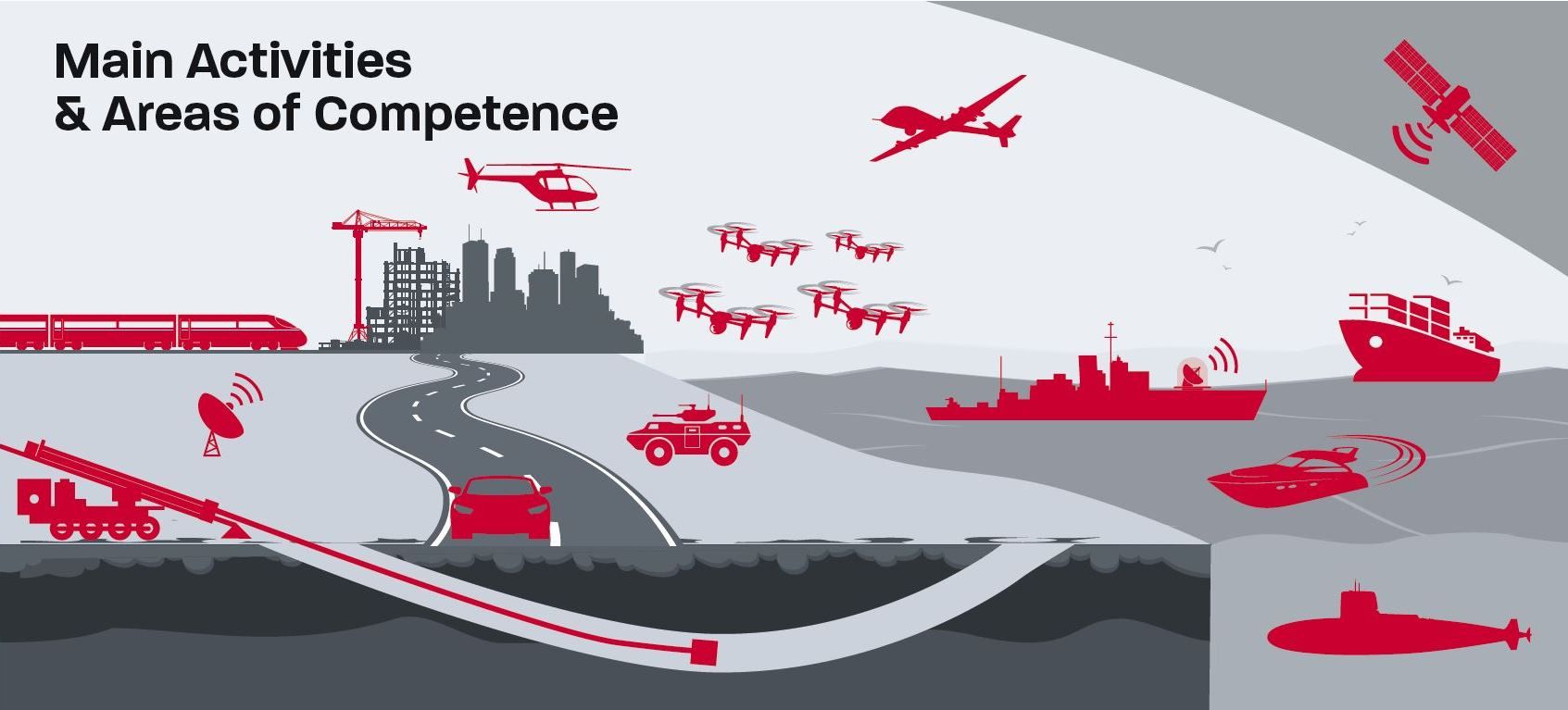
Railway Surveying, Train Localization, ADAS for Rail
Systems for public protection, for special forces, for protection of critical infra structures, which have also to work in GNSS denied envirnment
Localization, Navigation and Control of automated Land Vehicles in Harbor and Logistics
Localization and Guidance of automated or autonomous Vehicles in the Air, on Land, on Sea and in Subsea
Airborne Strapdown Gravimeters, geophysical Sensors
Surveying, Navigation and Localization for manned and unmanned Airborne Vehicles
GNSS Solutions, Signle- and Multi-Antenna Solutions, Localization, Space Applications
Stabilization of Cameras, Antennas, Weapons
Stabilizied Platforms for Cameras, Lasers, Antennas etc.
Horizontal Directional Drilling - Drillhead Navigation
Land Vehicle Localization, Navigation & Control, automotive Testing and Guidance of highly automated Vehicles
Military Applications: Localization, Guidance and Control, Stabilization of armed Vehicles, Trucks and Launchers
Transfer Alignment Systems for fast Optronics, Antenna and Weapon Alignment
Assistance Sensors: LiDAR, Radio Modems, Mesh-Communication, Wheel Sensoren,s Video Tracking, Stereo Vision, Magnetometers, AirData Sensors etc.
Military Applications on Land, on Sea and in the Air
Stabilized Platforms for Antennas, NightVision & Daylight Cameras and Lasers
Stabilization, Ride Control, Autopilot Systems, Gyro Compasses for manned and unmanned Ships and Ferries (also customized solutions)
Swarm Guidance & Control of autonomous or highly automated Vessels
Navigation and Guidance for unmanned und manned Submarines and Naval Weapons
Our discerning, experienced customers have trusted our expertise and solutions for over 30 years:


Note: The displayed logos are under the copyright of our customers. This representation is a small excerpt from our client list, which includes over 300 clients worldwide.