iPosCAL - ultra fast and accurate post-processing software for INS/GNSS/ODO data
Advanced post-proc software for general applications, pipeline surveying and gravimetry
iPosCAL is iMAR's advanced, easy-to-use, high accurate and ultra fast operating post-processing software for all kind of inertial based applications. It is designed for both, general surveying applications (using iMAR's iNAT, iTraceRT-MVT, iCORUS, iRail, iATTHEMO, iPST, iSULONA, iPRENA etc. inertial measurement systems) and applications with specific requirements, e.g. for inertial pipeline surveying (using iMAR's iPST systems) or airborne gravimetry (using iMAR's iCORUS systems).
The input data format for the data to be processed is iXCOM, which is iMAR's standard data protocol of all systems according to iNAT architecture (published). Furthermore all-frequencies / all-constellation RINEX 3 as well as the NovAtelTM rawdata format (GNSS as well as inertial SPANTM data) and others like SeptentrioTM GNSS raw data are supported as well as IMU data formats of third party manufacturers.
![]() The software iPosCAL allows the processing of a single data set as well as the fully automated batch-evaluation of larger survey campaigns, with up to hundreds of flights / tracks. The ultra fast processing allows the analysis also of very large data and measurement campaigns with several hundrets of objects covering strong performance requirements and fulfilling very short processing time following today's economic demands. The software is also available in a server version.
The software iPosCAL allows the processing of a single data set as well as the fully automated batch-evaluation of larger survey campaigns, with up to hundreds of flights / tracks. The ultra fast processing allows the analysis also of very large data and measurement campaigns with several hundrets of objects covering strong performance requirements and fulfilling very short processing time following today's economic demands. The software is also available in a server version.
In contradiction to most other post-proc software in the market, iPosCAL allows also the processing of data without any or very poor GNSS availability. Why? Most software in the market has its root in the GNSS area where we our base is 30 years of experience in inertial algorithms and advanced GNSS processing.
iPosCAL is available in several editions:
- iPosCAL-SURV, designed for IMS-based surveying, allowing the precise determination of position, velocity and attitude over time, along with the respective standard deviations. The software is designed for the full range of INS/GNSS applications: From low-cost MEMS up to highest performance with optical or hemispherical gyroscopes, thereby covering any industrial, automotive, railway, airborne, marine, surveying, defense and research applications.
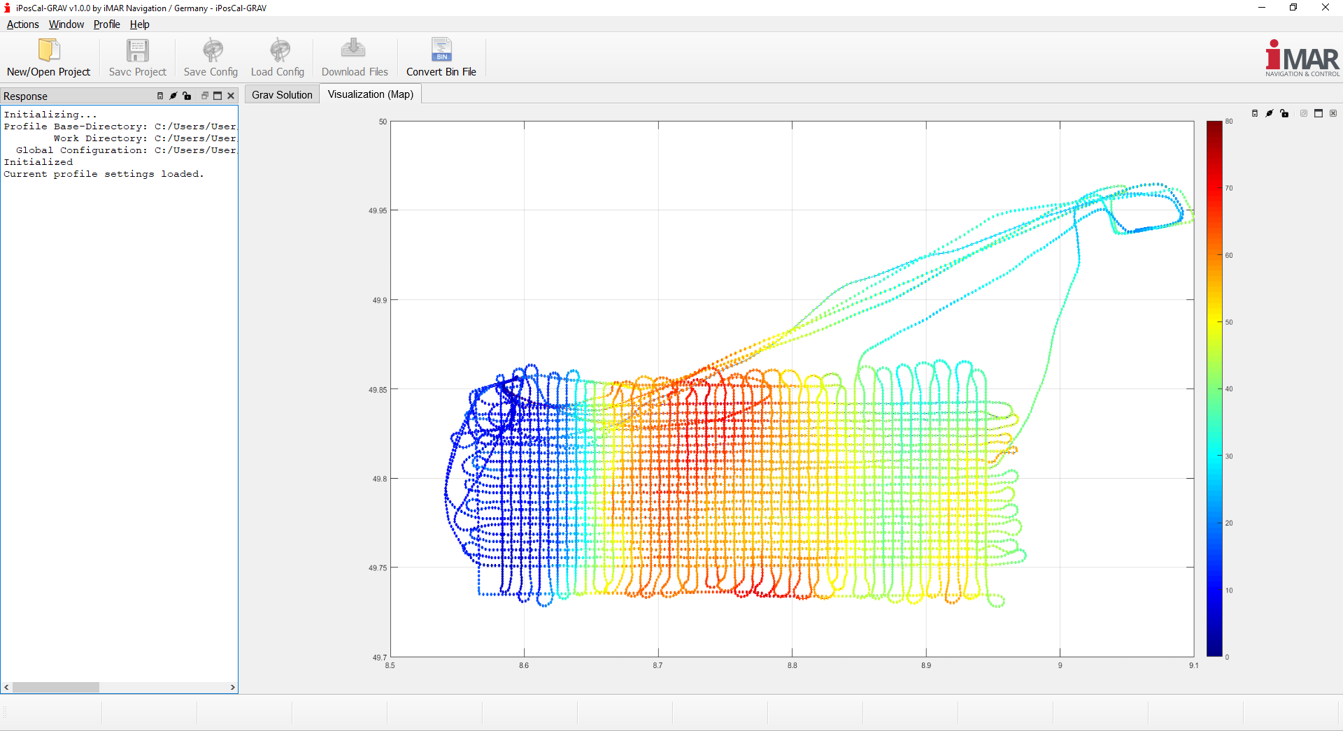
- iPosCAL-GRAV is designed for airborne or shipborne gravimetry campaigns, in combination with iMAR’s family of strapdown gravimeters iCORUS. On top of all the features of iPosCAL-SURV, it offers additional functionality for airborne or shipborne gravimetry: The automated determination of survey line endings, an automated generation of cross-over statistics as well as basic cross-over network adjustment methods, the generation of gravity map images, and more.
- iPosCAL-PST is designed for pipeline surveying using iMAR’s iIPST pipeline surveying tools. On top of all the features of iPosCALSURV, it offers additional functionality for specific pipeline related marker aiding procedures, specific odometer processing etc.
CAPABILITIES & FEATURES
All editions of iPosCAL offer an easy-to-use simple processing mode for the less experienced user, as well as an expert mode, allowing the fine-tuning of all relevant processing parameters, GNSS-arrays with multiple antennas, user-customizable output files, and much more.
- Position, velocity, attitude and standard deviation determination with exceptional performance.
- "Urban Canyon" capability - used and designed also for applications affected by very difficult GNSS environment.
- Ultra fast processing speed and very high accuracy including multiple-run processing (~5 seconds processing time per 1 hour measurement data).
- Determination of gravity (version iPosCAL-GRAV).
- Automated, batch-processing to handle even very large campaigns (command line interface availabe).
- Signal Processing: multi constellaion / multi frequency GNSS RTK/PPP, IMU and odometer data processing, filter and spectrum analyzer capability, lever arm estimator, odometer scale factor estimator, misalignment estimation, multi-turn calculation, expansion capability to additional measurements (DVL, LiDAR, radio beacons, SBL / USBL / LBL etc.), etc.